

History and Archaeology
The Journey to the Temple: Walking the Path of Our Ancestors
Beneath the Western Wall lies the path our ancestors once walked to the Temple. Through striking archaeological discoveries, this journey brings their footsteps to life and reveals how Jerusalem’s stones still echo with prayer and longing.
- Yosef Yabece
- | Updated
Those walking from the Jaffa Gate toward the entrance to the Western Wall can notice many archaeological exhibits on their right, in an area known today as the Davidson Center Archaeological Garden.
However, not many are aware of the significance of the stones standing there, that these silent stones represent a moving and fascinating testimony to Jewish life that flourished in this place during the Second Temple period.
Jerusalem’s Landscape in Temple Times
The Temple stood on a high mountain, namely the Temple Mount. The Jerusalem of the Temple period also stood on a high mountain, located to the west of the Temple Mount, known as Mount Zion, on which today stand the Jewish Quarter and the Armenian Quarter of the Old City of Jerusalem.
Between them, at the foot of the Western Wall, there was a large and deep gorge, referred to by the Romans as the Tyropoeon. The Tyropoeon divided Jerusalem from side to side, from the Damascus Gate in the north, along the route that today is crossed by Haggai Street in the Muslim Quarter, through the Western Wall plaza today, and afterward the Israelite Courtyard, until it exited Jerusalem to the south near the Jaffa Gate.
In modern times, Haggai Street is no longer such a deep gorge, since during the destruction of Jerusalem, the ruins were dumped into the gorge and covered with sand. Later, houses were built upon the ruins and destroyed again, gradually raising the level of the ground. Originally, however, there was a gorge so deep between the city of Jerusalem and the Temple Mount that even the Western Wall, excavated many meters deep, has not yet reached its original bottom.
So how did our ancestors ascend from Jerusalem to the Temple Mount? How did thousands of pilgrims, accompanied by many animals for sacrifice, rise from the deep gorge to the Temple Mount plaza, which stands dozens of meters above it?
The Bridge and the Main Path of the Pilgrims
Indeed, there is one bridge that spans the valley, connecting the city of Jerusalem with the Temple Mount. This bridge still exists today, and one can still see the enormous original arch standing at its base. If we enter the prayer tunnel located to the south of the Western Wall plaza, toward the end of the tunnel we can see a huge arch rising from the stones of the wall. This arch is known as Wilson’s Arch, and above it passes the bridge connecting the city to the Temple Mount.
This bridge was built to provide a direct passage from Herod’s palace, located in the area where the Tower of David stands today, to the Temple Mount, along a route now called the Market Road, directly to the Gate of the Chain.
However, this bridge did not reach the main entrance to the Temple Mount. It led behind the Holy of Holies, not to the entrance used by the pilgrims.
The Mishnah in the tractate of Midot teaches that there were five gates to the Temple Mount, including two Hulda Gates in the southern wall that served as entrances and exits. Rabbi Ovadia of Bertinoro explains that these were the gates through which people entered and exited the Temple Mount. The primary entrance for the public was indeed through the two gates in the southern wall.
How, then, did our ancestors reach those gates? Can we trace the path of the pilgrims as they ascended to the Temple?
Walking in the Footsteps of the Pilgrims
This is where the role of the archaeological garden becomes so powerful. It tells the story of the pilgrims step by step on their journey to see the face of Hashem.
In the garden area, researchers excavated at the foot of the Western Wall until they uncovered the face of the gorge as it appeared during the Temple period. In this way, the story of the route taken by our ancestors on their ascent to the Temple was revealed.
First, the pilgrims descended from the city into the gorge, just as we descend today toward the Western Wall plaza.
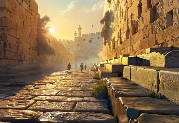
At the bottom of the gorge, one can see a street paved with original stones stretching along the foot of the Western Wall. Upon these stones, our ancestors walked with excitement on their way toward the southern wall and the gates of the Temple.
To their left rose the Western Wall. To their right stood a strong stone wall containing three niches that served as shops selling the needs of the pilgrims: animals, oil, and flour. In one of the shops, a carved ring in the stone can still be seen. This ring was used to tie the animals that were sold for sacrifices.
Before reaching the shops, one can see a staircase leading to a courtyard behind the wall. In this courtyard are more than ten ritual baths, where thousands of pilgrims immersed themselves before ascending to the Temple Mount.
Afterward, purified and prepared, the pilgrims continued with their offerings in hand until they reached the corner of the southern wall. They turned left and began walking along the street that runs beside the southern wall. This area has not been fully excavated to its base due to later Crusader and Muslim layers.
They continued along the southern wall until they reached the Ophel.
The Ophel is the name used in the books of Nehemiah and Chronicles for the area south of the Temple Mount. Here the slope is gentler than on the eastern and western sides, allowing for a gradual ascent from the City of David, located below the Temple Mount to the south, toward the height of the Temple Mount plaza.
At the top of the Ophel, original steps from the Temple period still exist. These steps climb from the Pool of Siloam at the lowest point near the City of David up to the southern gates of the Temple Mount.
Pilgrims arriving from the western street would join these steps partway and ascend through them to the Hulda Gates, which can be seen where the steps end at the southern wall.
Each day during the festival of Sukkot, all of Israel would descend with song and dance from the Temple courtyard to the Pool of Siloam and ascend again on these very steps to bring the water for the water libation ceremony. A tunnel excavated beneath Silwan reveals these steps in their full length up to the Pool of Siloam.
Stones of Memory and Destruction
If we return to the street at the foot of the Western Wall and move forward about one hundred years to the time of the Roman siege, we can imagine the disciples of Rabbi Yochanan ben Zakkai walking upon these stones while carrying their teacher in a coffin to save him from the zealots and bring him to the camp of Vespasian on the Mount of Olives, as described in the Gemara.
Even the destruction itself is visible on this street. The entire roadway is scattered with large stones that were hurled down from the top of the Western Wall when the Romans broke into the Temple Mount.
Among these stones lies the corner stone that once stood at the top of the wall at the southwestern corner. Upon it were carved the words "Home of the Ram’s Horn."
In this stone, a depression was carved where a priest would stand on the eve of Shabbat and blow the shofar to announce the cessation of work, as described in the Mishnah in the tractate of Sukkah.
